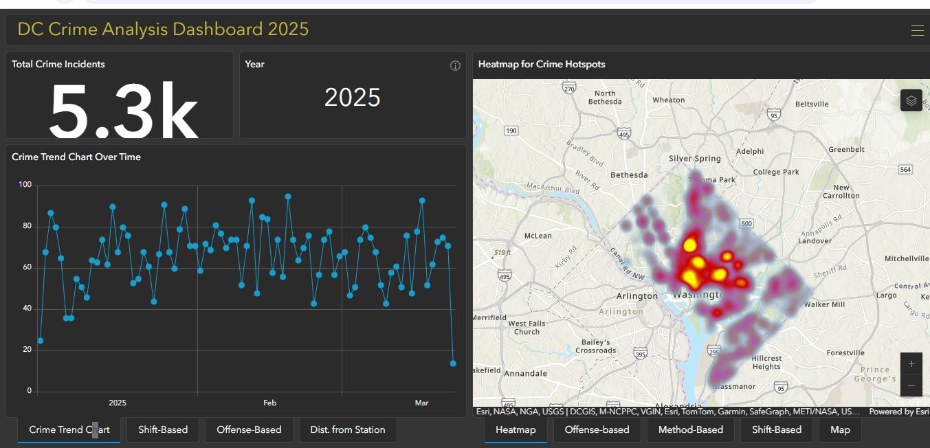
This interactive ArcGIS Online dashboard provides an in-depth analysis of crime patterns in Washington, D.C. It features crime heatmaps, hotspot analysis, and proximity assessment to police stations. Users can explore crime trends using a time slider, analyze gun-related incidents, and filter data based on crime type and shift.
Soil mapping is the process of delineating and classifying natural bodies of soils, and capturing soil property information for interpreting and depicting soil spatial distribution on a map. Soil maps are essential tools for land use planning, sustainable agriculture, environmental management, and natural resource conservation.
LIST OF SPECTRIAL INDICES
• Normalized Difference Vegetation Index (NDVI)
• Normalized Difference Moisture Index (NDMI)
• Soil Adjusted Vegetation Index (SAVI)
• Normalized Difference Water Index (NDWI)
• Green Normalized Difference Vegetation Index (GNDVI
)
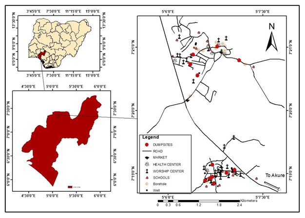
Open dumpsites are uncontrolled and unengineered waste disposal sites with no measures to
protect the environment or public health. Soil contamination by heavy metals poses risk to human
and ecological health. In recents years, the use of satellite data integration, time series analysis and
hotspot analysis have been used to assess and map the impacts of heavy metal contamination in
soils. This research made used of interpolation tool: inverse distance weighting (IDW) to estimate
heavy metals concentrations at unsampled locations and identify affected area using buffering and
overlay analysis. GPS data, Landsat and DEM to determine coordinates of dumpsites, LULC, and
slope and area extents of the study area. 12 soil samples were collected from different dumpsites
locations, heavy metal concentrations for copper, cobalt, chromium, cadmium, iron, nickel, lead,
and arsenic were measured. Spectral reflectance curves were acquired for soils using
spectroradiometer. The concentrations of the heavy metals were below WHO limits, though
isolated contamination was found for cobalt and nickel. Spectral reflectance curves (350-900 nm)
showed variability indicating compositional differences between sites. Buffer analysis highlighted
9 schools, 4 health center, and infrastructures within risky proximity to dumpsites. GIS
multicriteria evaluation integrated factors like slope, distance from sensitive receptors, and
accessibility to generate a suitability map for new controlled dumpsites. Results indicate current
dumpsites pose localized risks to soil and communities. While heavy metal accumulation is not
yet widespread, the unregulated dumping practices merit intervention. Community engagement,
and phytoremediation in buffer zones can help mitigate ecological and public health impacts.
Keywords: Buffer Analysis, GPS (Ground Positioning System), Heavy Metal, Inverse distance
weighting (IDW), Spectral Reflectance Curve.
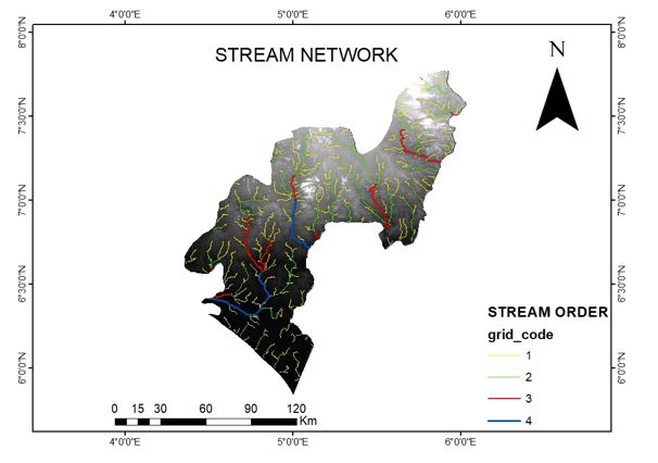
The aim of stream order and watershed mapping is to understand the hierarchical organization of streams and the drainage patterns within a given landscape. These provide valuable information for various applications in hydrology, ecology, and water resource management.
.
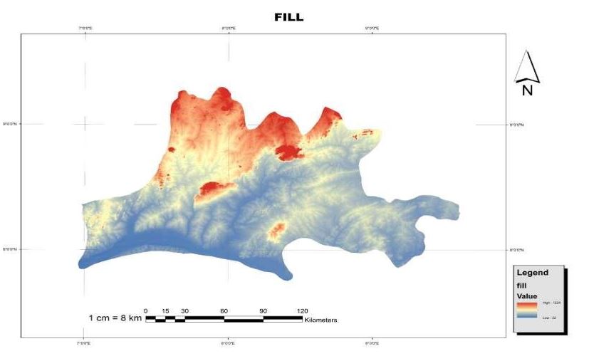
Application of Remote sensing and GIS have open a new ways of estimating different
hydrological and surface structure of Nasarawa, examples are the flow direction, flow
accumulation, basin, stream order Hill shade, contour and slope direction of the area of
target. With the use of Remote sensing software known as Arc Map..
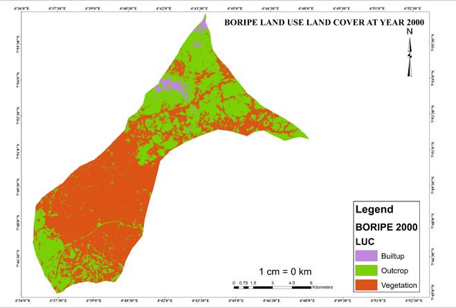
One of the most important functions of remote sensing data is the production of Land Use and Land Cover maps and thus can be managed through a process called image classification. This project looks into the following components related to the image classification process and procedures and image classification techniques Boripe local government.
In this kind of classification we make use of Supervised image classification which is based on the idea that a user can select sample pixels in an image that are representative of specific classes and then direct the image processing software to use these training sites as references for the classification of all other pixels in the image.
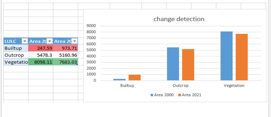
Geo-spatial assessment of land use/ Land cover dynamics in Boripe Local Government was instigated to bridge the knowledge gap created by data deficiency on the nature, scope and magnitude of land use/ Land cover change in the area. This was done through the analysis of Landsat images of two years from 2000 to 2021.
.
The study utilizes remote sensing datasets, including:
- LST (Land Surface Temperature) – Extracted from thermal satellite imagery.
- LULC (Land Use Land Cover)
– Classified using satellite data to differentiate land cover
types.
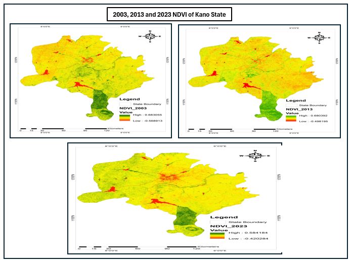
- NDVI (Normalized Difference Vegetation Index)
– Assesses vegetation health and density.
- NDWI (Normalized Difference Water Index)
– Detects water bodies and moisture content.
- SAVI (Soil-Adjusted Vegetation Index)
– Enhances vegetation signal while reducing soil brightness influence.
- Rainfall Data – Correlates precipitation trends with land surface changes.
Analytical tools such as ERDAS IMAGINE, QGIS, and ArcGIS were used to process and
analyze these datasets..